Counties
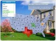
USA Real Estate Map
USA Real Estate (RE) Map dynamic solution to: - show RE data as a bright map instead of long lists - show info in any sphere other than RE as long as it is shown on state/county level - show info by changing state colors, show tooltips and
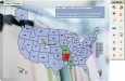
Dealer Store Locator Map (USA)
Interactive Flash Dealer Store Locator is a unique vector-based tool with the administrative mode that helps you originally represent the information about your business locations in the US in the simplest way. USA Flash Dealer Store Locator Map covers
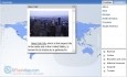
World Map in Flash
XML-driven World Map in Flash is a powerful, full-featured, and flexible mapping solution to present any kind of business or personal data worldwide. It took web-mapping experience, intelligence and time to deliver a solution we are proud of. The main
International Cricket Captain 2010 v.1.0
Take control of your favorite side from the English County, International or Australian Domestic system. You control your team's fortunes. Have you got what it takes to be a world champion?
GedHTree v.2 80
GedHTree is a program for Windows 95 through XP, Vista and Windows 7 users that processes GEDCOM files to generate output pages in HTML format. Share your family genealogy with others on the Web, by CD-ROM, etc. GedHTree is only available in English.
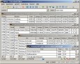
GeoclipSolo v.2.5.0.33
Géoclip Solo includes a building tool which is described above. It also includes a base map conversion tool (see picture opposite). The geographic layers which are assembled to build a géoclip are in the swf format.
Know Your Europe v.2 2
Know Your Europe is a map based Geography application designed to help people of all ages to develop and test their knowledge of European geography through both English and Irish.
SESE Interactive v.2.5.0.26
SESE Interactive Software, award-winning designer uses proven formula to make it easy and exciting to combine the teaching of history, geography and science, so that each complements the other perfectly.
Geo Data German Admin (English) v.10 2
Geodata of the Federal Republic Germany with municipalities, postal codes, telefone preselections. Suitable for branch searches, periphery searches and distance computations. Georeferences as Gauss Krueger, UTM and geographic coordinates. ORTREF:
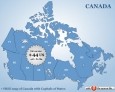
Canada Flash map with FLA source v.1.0
Canada Flash map (with FLA source) for web sites, interactive applications, presentations, and more. With this fully-clickable map you will be able to improve navigation and provide visitors with better and quicker access to information as well as

World City and Countries Database v.1.0
WebLocations and WebGeocities are two cities databases offered for user download. They differ in geo co-ordinates only.
International Cricket Captain v.10.16
International Cricket Captain is back for the fascinatingly poised 2010 season. With up to date competitions, outstandinger realism, and packed with features and stats, Cricket Captain 2010 will once again raise the bar in cricket management gaming.